Weather and Climate National Weather Service Forecasts: Serving Agriculture
Introduction
The Great Plains is known for rapidly changing weather. Checking weather forecasts is a daily ritual for residents of the central United States as they determine if they should prepare for calm seasonable weather, or for severe storms, extreme blasts of cold, deadly blizzards, roller-coaster temperatures, blistering hot days, extended droughts, and torrential downpours.
With today’s instant communication, individuals can directly access NWS’s weather and forecast products from a smartphone or the internet. This publication focuses on forecasts produced by the NWS that can be used in agricultural decision making.
These forecasts provide farmers, ranchers, and land managers the information they need to make decisions regarding safety in severe weather, help maximize the use of farm inputs, and minimize production risks.
The NWS uses the term “forecasts” for short-term forecasts that look ahead hourly, up to seven days. For longer time spans, they produce “outlooks.” Forecasts and outlooks are presented differently, and use different statistical logic.
Outlooks present the probability of being in one of three categories: above normal, near normal, or below normal for weeks and months ahead. These probabilities are based on the climate normal range from the three most recent decades. Geographical areas covered by outlooks are large, multi-state regions.
Forecasts
To create a forecast meteorologists sift through large amounts of data from surface observations, weather balloons, radar, satellite, and computer models. They combine these bits of information to produce forecasts varying from minutes to days ahead.
NWS forecast products predict weather conditions ahead for the next seven days. Forecasts contain multiple weather variables, including: air temperature, dew point temperature, relative humidity, wind speed, wind direction, rainfall or frozen precipitation, and sky cover. Forecasts predict a value or indicate the probability of precipitation for specific geographical areas. Forecasts are available for regional zones down to point forecasts on 1.6-mile grids.
Forecasts are updated as needed to address public safety needs and forecast accuracy of weather conditions. When weather is stable, forecasts are updated less often. When conditions are changing rapidly, forecasts are updated more often.
Mobile Device Access
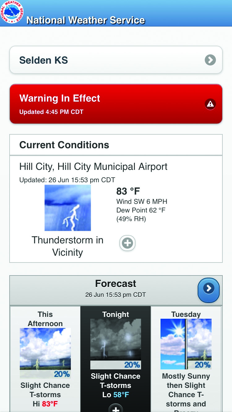
To access NWS forecasts on a mobile device, enter “mobile.weather.gov” into your mobile device’s browser app. On the landing page, enter a city and state or ZIP code. Entered locations are automatically saved for quick forecast access. Touching the “Go” button brings up the location, any special weather statement or hazardous weather advisory, and current conditions (Figure 1). The statement or advisory includes a warning symbol that provides detailed information. The plus symbol in the “Current Conditions” box brings up additional weather data and details about the observed location.
Figure 1. NWS mobile.weather.gov
Scroll down to see next viewable box, “Forecast” (Figure 1). It includes forecast information for the next 36 hours, navigation arrows to advance or backup the forecast, plus symbols to go to hourly forecasts, and a “Detailed Forecast” that provide more information. Other menu tabs link to: Radar, Satellite, Forecast Discussion, Forecast Graphics, Rivers/Lakes, Tweet a #wxreport, Tropical Weather, Marine/Tides, Astronomical Data, Tsunami, Full Site, FAQ, Site Info, and Feedback.
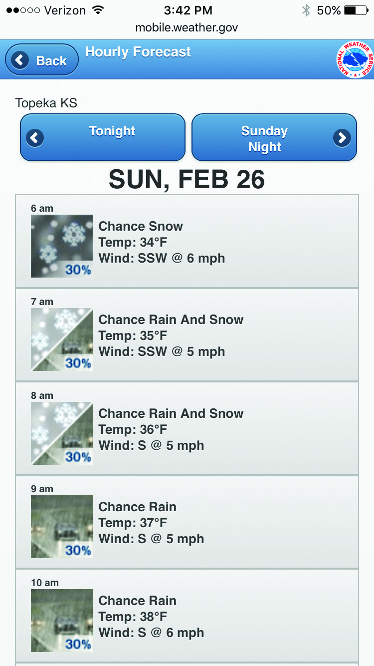
To dig deeper into the forecast, the “Forecast” box offers a number of options. Use the arrows to move forward to see day and night forecasts for up to 7 days. Touching the plus button in the box for any day or night displayed brings up the hour-by-hour forecast (Figure 2). The hourly forecasts include: general weather, temperature, wind direction, and wind speed. When there is a chance of rain, thunderstorms, snow, or other frozen precipitation, the probability of precipitation is shown as a percent with the weather type icon.
Figure 2. NWS mobile.weather.gov – Local hour-by-hour screen
Weather.gov and Your Forecast Office
The NWS’s full website is weather.gov. Users have the choice of viewing point forecasts for a single location or seeing nationwide forecast maps. The weather.gov homepage shows all active watches and warnings on maps of the United States (Figure 3).
Figure 3. NWS – weather.gov – webpage
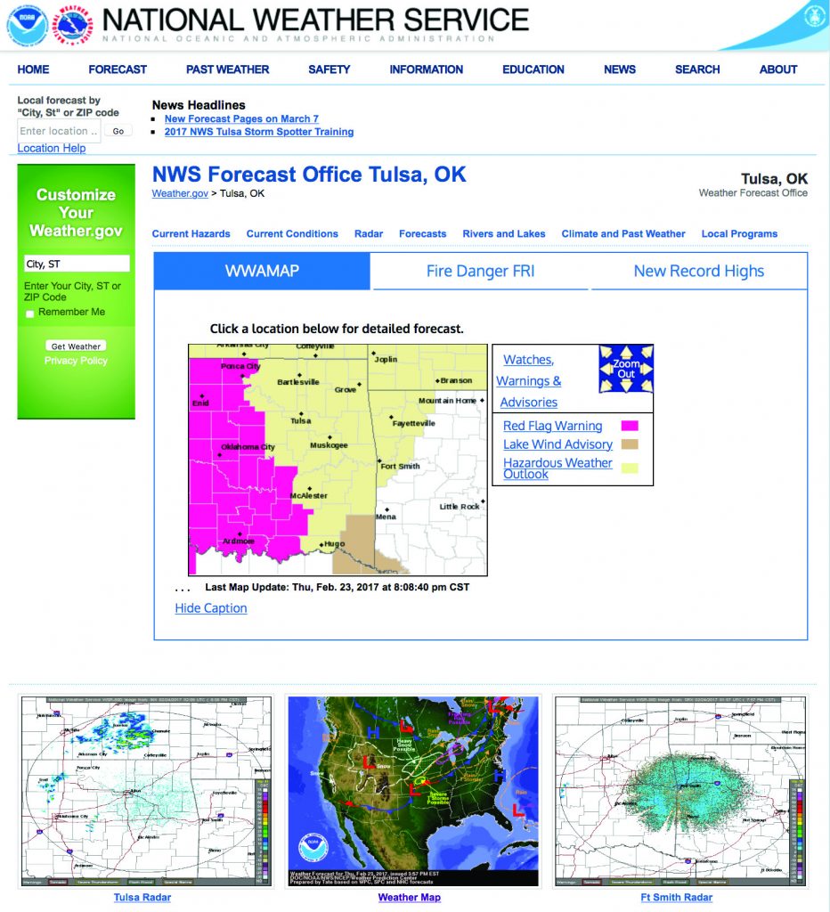
The weather.gov homepage is an interactive map that allows users to select their local NWS office’s forecast homepage (Figure 3). Select an area on the map to go to the home webpage for that local office. There are 122 forecast offices across the continental United States.
Local forecast office home webpages vary (Figure 4). An interactive map of the local forecast office’s service area takes users to a point forecast webpage. The page may include one or more “Graphicasts” or “Weather Story” items. These are regional weather graphics that highlight weather of note or concern. Other products on the page include local radar, weather maps, and text and icon product selection (Figure 4).
Figure 4. NWS – Local Office – webpage
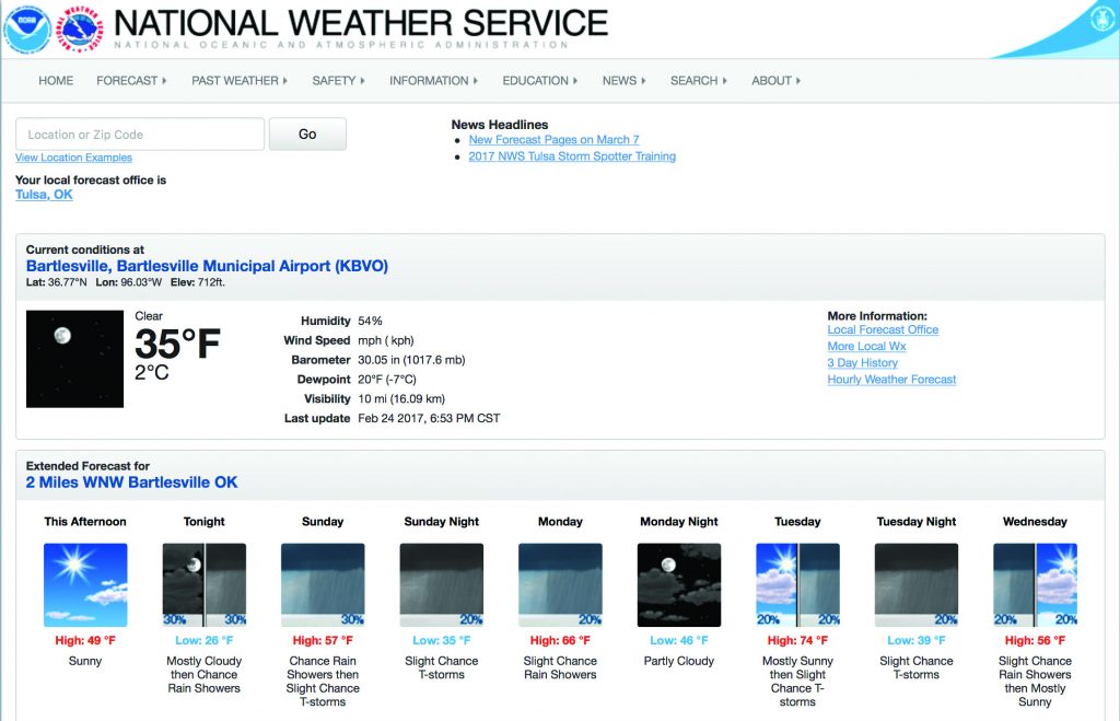
The point forecast page lists the local office toward the top of the page. If there are any hazardous weather statements or advisories, they are listed next in red highlights. Below that are weather data from the closest National Weather Service weather station. After that is a day and night capsule forecast covering the next 5 days and nights (Figure 5).
Figure 5. NWS Point Forecast Page
Scrolling down the page brings up the “Detailed Forecast” for the next 7 days. This is a text forecast that often includes information on wind speeds, gusts, precipitation timing, precipitation amounts, and changes from rain to frozen precipitation.
To the right of the “Detailed Forecast” is an interactive map showing the “Point Forecast” area. Just below this box are the date and time of the last forecast update and the dates and times the forecast covers.
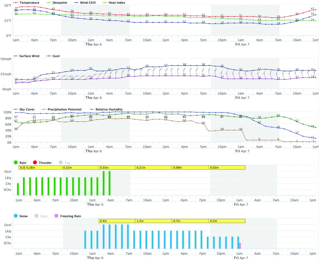
Farther down the page is the “Hourly Weather Forecast Graph” (Figure 6). This is one of the most powerful forecast tools available. It provides time series graphs of hourly forecast weather variables over a 48-hour period. Variables that can be graphed, include: temperature, wind, relative humidity, rain, thunder, and other types of selected weather variables. An interactive time and date box can be used to start the graph from any date and hour to view hourly forecasts for as long as seven days. Users can turn off or on weather variables or conditions listed above the graphs or graph legend.
Figure 6. NWS – Hourly Weather Graph
The time series shows how temperatures will change over the day or when a cold front is coming through. The wind graph shows shifts and if the change occurs during times of high wind speed. Graphs show when there is a chance of precipitation and whether it will come as rain or as frozen precipitation. Yellow shaded boxes show likely rainfall or frozen precipitation amounts over hours covered by each box, if precipitation occurs. Grey shading indicates nighttime hours and white, daytime hours.
The NOAA NWS is constantly seeking to improve forecast accuracy and weather product delivery. They produce a wide variety of quality products that can help farmers and ranchers improve their operation’s management.
What Does A Chance of Rain Mean?
The “chance” is the likelihood of measurable precipitation that is at least 0.01 of an inch of rain at a location during a specific time period (usually 3, 6, or 12 hours). The “chance of rain” is also called probability of precipitation.
What Does This Really Mean?
A 40 percent chance of rain means there is a 40 percent chance your location will receive at least 0.01 of an inch of rain during the specified time period.
What A Chance of Rain Doesn’t Tell You
How Long It Will Rain?
It could be a brief rain shower or several hours of rain as long as at least 0.01 of an inch of rain is measured during the time period.
How Much It Will Rain?
A minimum of 0.01 of an inch is needed. If the conditions are right, a location could receive as much as several inches of rain with only a forecast of 20 percent chance of rain.
NOAA National Weather Service
The National Weather Service (NWS) (weather.gov) is part of the National Oceanic and Atmospheric Administration (NOAA) (noaa.gov). NOAA is administered through the United States Department of Commerce. NOAA monitors and investigates our world, from the surface of the sun to the depths of the ocean to keep citizens informed of the changing environment.
Albert Sutherland
Oklahoma Mesonet Agriculture Coordinator, Oklahoma State University
Mary Knapp
Assistant State Climatologist, Kansas State University
Peter Tomlinson
Environmental Quality Specialist, Kansas State University
Lana Barkman
former Great Plains Grazing Extension Project Coordinator, Kansas State University
Erin Maxwell
NOAA NWS, Norman Forecast Office
Todd Lindley
NOAA NWS, Norman Forecast Office

