Natural Stream Restoration and Enhancement
Introduction
Streams change over time, both naturally and from human interference. Changes can alter the natural balance of the stream corridor, resulting in reduced water quality, wildlife habitat and increased erosion. When streams are restored to a more natural state, these detrimental effects can be reversed, or at a minimum their negative impact reduced. Stream corridors can be restored in several different ways, but the most beneficial to the environment is natural stream restoration. Natural stream restoration is a multi-step process in which objectives are defined, the stream is assessed, the best course of action is determined, and restoration design and construction occurs. Following this process while incorporating natural materials and native vegetation into the design will help bring the essential services of the stream back in balance.
This Fact Sheet will describe the make-up of a stream corridor, common conventional stabilization techniques, the natural stream restoration and enhancement process with specifics of the design component, and an example of natural stream restoration in Oklahoma. See the glossary at the end for definitions of the words in bold.
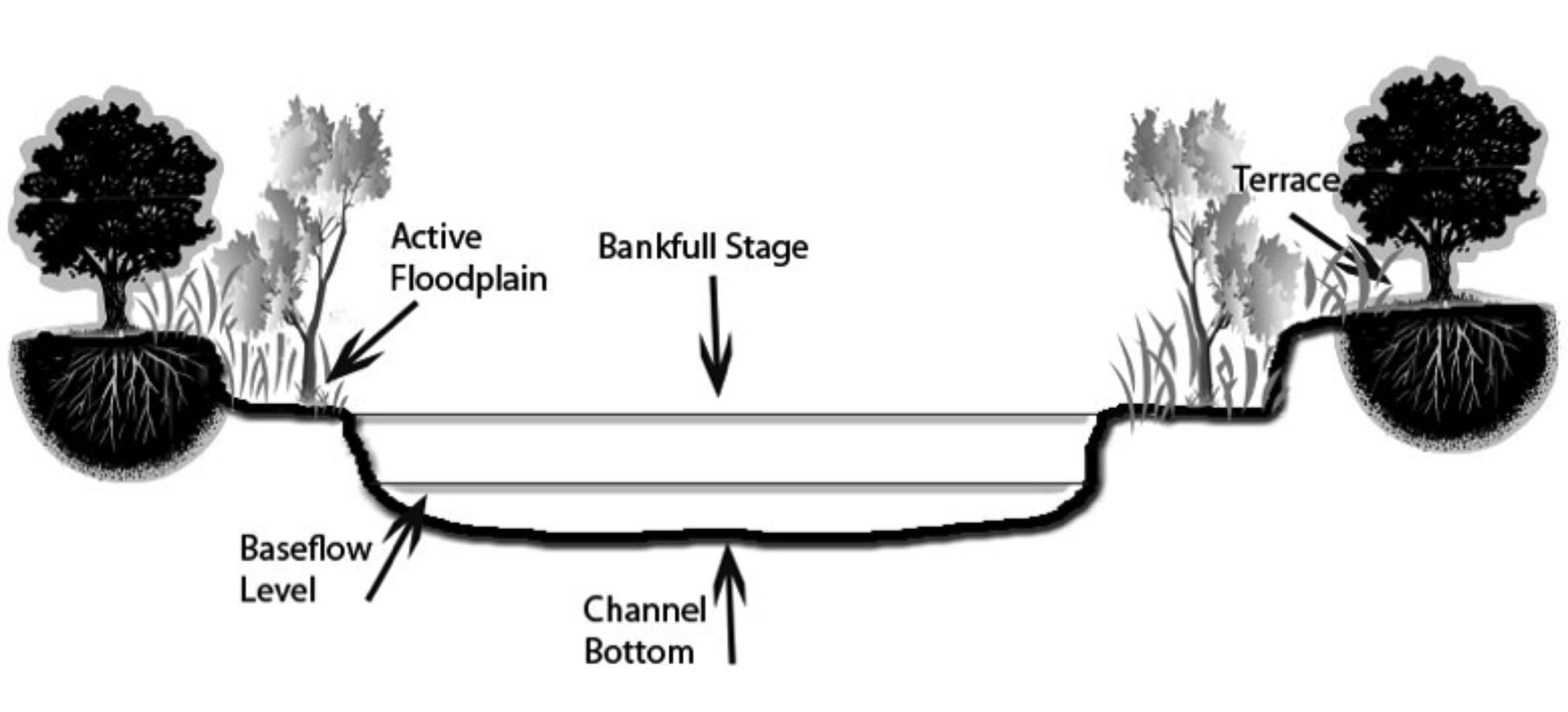
Figure 1. Cross-section of stream corridor with major components labeled.
Stream Corridor Properties
The stream corridor consists of the carved out channel bottom that contains flowing water at least part of the time, the floodplain and the transitional upland fringe (Figure 1). The water level and velocity will vary as a result of slope, rainfall and snowmelt. An increase in the amount of water can exceed the carrying capacity of the channel and results in water spilling onto the floodplain. The transitional upland fringe is a higher elevation area that separates the floodplain from the surrounding landscape.
Trees and vegetation play an important role in the stream corridor and offer many services to the stream ecosystem. Trees and their roots help stabilize the bank, reduce erosion and provided needed shade; vegetation serves as a filter for pollution and sediments carried into the stream. The stream corridor also provides essential habitat to both aquatic and terrestrial species. Woody debris in the stream provides a place for macroinvertebrates to feed, which in turn serve as a food source for many fish species. Small pools in the channel bottom and rocky formations serve as breeding grounds for fish. The floodplain and upland area provide forage and habitat for mammals and reptiles. Streams provide many benefits to humans as well — recreational opportunities and add aesthetic value to the landscape. Good fish habitat will bring out the anglers; sufficient flow and cool, inviting water means canoes and rafts will abound. A healthy riparian area with trees for shade can serve as campground or picnic areas. All of this together provides an economic benefit to the communities along the corridor.
For more information on streams and their functions see Extension Fact Sheet NREM-9208 Understanding Streams.
Stream Corridor Degradation
While humans derive many benefits from a stream corridor, they can also be the major cause of a corridor’s degradation. Human impacts to the stream corridor include land development for both urban and agriculture use. Clearing the riparian area allows more pollutants to flow into a stream from either manicured and well fertilized lawns or plowed fields. Allowing cattle access to the stream for water can degrade the stream bank, loosen soil and increase bank erosion. Use of concrete and asphalt on the landscape increases runoff into the stream rather than seepage into the ground. This increases the amount of debris and pollutants flowing into a stream. Improper grading of dirt roads and lack of vegetation in the ditches allow more sediment to flow into a stream, increasing the turbidity (cloudiness) of the water. An increase in the amount of nutrients entering a stream can increase algae growth, which in turn can decrease the amount of oxygen in the water and the variety of organisms the stream can support. The introduction of non-native plant species can cause native species to die off and limit natural food and habitat for the areas wildlife. They can also increase bank instability if their root systems are not deep or sturdy enough to help stabilize a bank. All of these issues decrease the value of the stream corridor. Figure 2 is an example of bank erosion and land loss on the Illinois River.
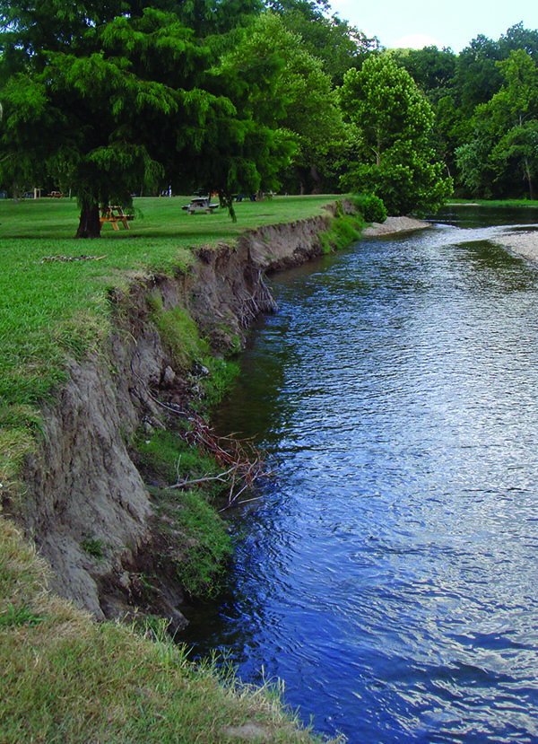
Figure 2. An example of bank erosion and land loss on the Illinois River.
However, not all changes to a stream are caused by human interaction. A stream naturally changes with time. Sediment gets washed in and the stream channel reshaped. The difference between natural changes to a stream and those caused as a result of human interference is the time span of the change and the ability of the stream system to adapt to the changes. Since streams are normally in a state of dynamic equilibrium, the stream is able to rebalance itself as these changes occur.
One of the biggest problems resulting from the degradation of the stream corridor is the increased amount of sediment going into a stream system. The sediment can be large or small and will either continue to flow downstream or settle into the stream bed. Sedimentation is the number one water quality issue in the U.S. Oklahoma has more than 4,012 stream miles of impaired waters based on turbidity and 151 miles are impaired due to sedimentation/siltation.
Once soil or other solid material enters a stream, it often becomes suspended in the water. The material is referred to as suspended sediments or solids and causes the water to be turbid. Sedimentation occurs when the solids begin to settle out of the water to the stream bed, changing the level of the stream bed. What does not settle out in the stream will ultimately settle in the water body the stream feeds, resulting in faster siltation of lakes, thereby reducing the lakes’ holding capacity.
Water Velocity and Sedimentation
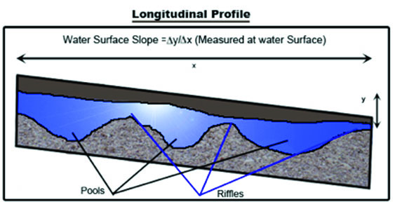
The velocity and type of sediment will determine what the sediment does. As the velocity of the water increases, so does the ability of the stream to carry sediments. Once the water slows, heavier sediments settle out of the water and drops to the stream bed. With time, this can change the form of the bed and the biological makeup of the stream. Figure 3 shows the slope of a stream and the pools and riffles that form in the deep and shallow areas of the bed. As the velocity increases, more sediment is pulled into the water and carried downstream. As the velocity decreases, the amount of sedimentation increases.
One way sediment enters a stream is from bank erosion. This can result in large amounts of soil, rock and other debris either falling or being washed into a stream. Bank erosion happens when changes occur to the bank’s slope from raising or lowering the stream bed, redirection of stream flow around obstructions in the channel, or from removal of stabilizing vegetation. Often the bank becomes more vertical and loses almost all vegetation, resulting in destabilization.
Bank erosion happens in two ways, bank scour and mass failure. Bank scour occurs when the speed of the water and its erosive power increases along the bank, removing bank material. Mass failures occur when large chunks of the bank collapse into the stream. Figure 4 shows a mass failure, resulting in a tree and section of land toppling into a river.
To mitigate some of these issues, several techniques have been developed to stabilize banks, reduce erosion and mitigate the effects of flooding.
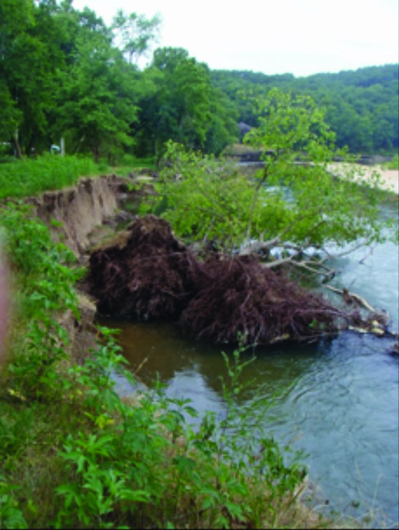
Figure 4. A tree toppling into a river is a sign of a mass bank failure.
Common Conventional Stream Stabilization Techniques
Some commonly used stream stabilization techniques include lining channels with concrete, stabilizing the bank with riprap (graded stone or crushed rock) and the use of gabions (metal cages that hold stabilization material in place). Tires and broken concrete have also been used as a rip rap material along a stream bank. The benefits of using rip rap to stabilize banks include relatively low costs, simple construction and ease of repair. Vegetation planted between the rocks provides increased stability and wildlife habitat. Rip rap can help decrease sediment loads and improve water quality. However, it does have limitations. The addition of rip rap can harm an area that has a healthy riparian vegetative community and habitat that includes shade, some stable undercut banks and large woody debris. It can alter the habitat, negatively impacting the flora and fauna. In addition, rip rap is not aesthetically pleasing.
Lining a stream channel with concrete is another method used to manage water flow and stabilize banks. Many cities across the U.S. use these channels to move stormwater quickly away from developed areas to help reduce flooding. This method is effective; however, it too has limitations, and while solving one problem, may create another. Everything that is washed into these channels is carried to the stream, lake or ocean that serves as its outlet, increasing water pollution. Since these channels are impervious, water cannot seep into the ground. They are often not aesthetically pleasing and limit the amount of wildlife in the area, as they typically have water in them for only a short time after a storm event. See Figure 5 for examples of common conventional stream stabilization techniques. While these techniques can reduce bank erosion and move water rapidly out of a localized area, they are not always beneficial to the environment and reduce the natural beauty of an area. Their use can actually increase water quality problems rather than decrease them.
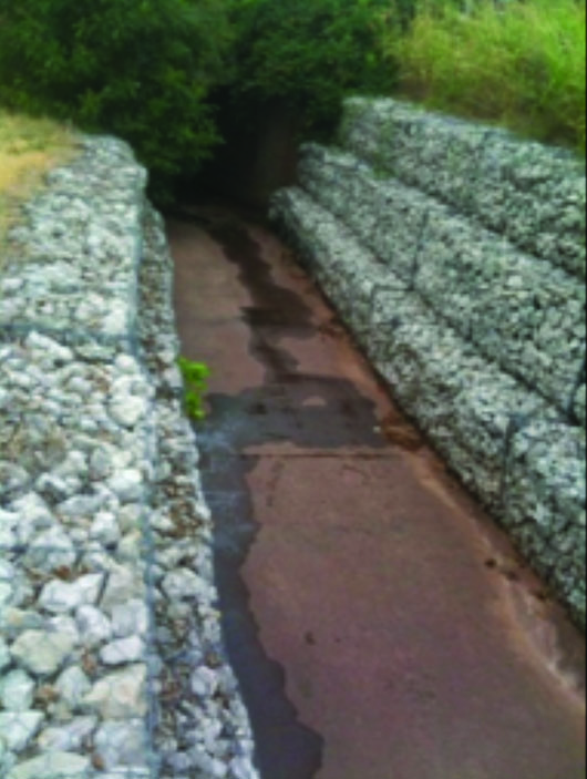
Figure 5a: Concrete channel lined with riprap held in place with gabions in Stillwater, OK
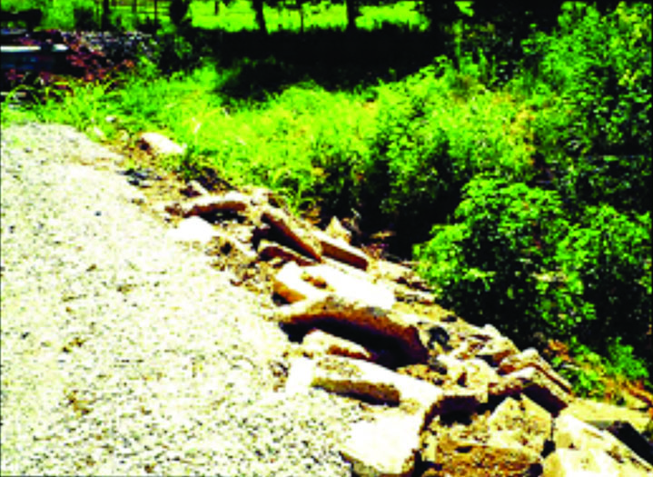
Figure 5b: Stabilizing the bank with riprap (graded stone or crushed rock)
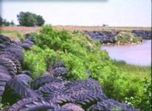
Figure 5c: Tire riprap along the Red River
Figure 5. Concrete channel lined with riprap held in place with gabions in Stillwater, OK (A). Tire riprap along the Red River and concrete chunk riprap (B and C).
Natural Stream Restoration Process
Natural stream restoration techniques can improve water quality, enhance aesthetic value, improve wildlife habitat and enhance floodplain function. A successful natural stream restoration project requires following a multi-step process to ensure thorough consideration is given to the planning and design stage before any work in the stream corridor occurs. The first step is to define the objectives. These may vary, but commonly are a combination of goals including; flood control, improving recreation, improving habitat, or reducing bank erosion. Once the objectives are determined, the current condition of the stream should be assessed. The assessment step involves noting any downcutting or widening; the amount, type, and condition of bank vegetation; changes in the watershed upstream; or features downstream that are constricting flow. Defining the goal and assessing the stream are two essential steps of the natural stream restoration process to provide the foundation for decision making during the final two steps.
The third step is determining the best course of action. Not all restoration work requires extensive manual labor or costly construction. A potential solution is to allow the stream to fix itself. This option may include doing nothing or removing stressors such as livestock or mowed stream banks. Fencing cattle away from the stream or developing a grazing plan allows vegetation to stabilize the banks and restore balance. Allowing the vegetation near the bank to grow wild instead of mowing it short will increase bank stability. A buffer between mowed areas and the stream can achieve this. If the minimal course of action is not enough, then a re-vegetation plan should be considered. A re-vegetation plan should include a list of native plants to be used, planting locations and timeline, and a monitoring and maintenance strategy. When leaving the stream alone or adding vegetation is not enough to achieve the objectives, then the stream needs to be redesigned and construction should occur.
The stream restoration design and construction involves reshaping the stream channel and floodplain, building in-stream structures, and protecting the bank. Dirt and rock are moved to reshape the channel to a natural form that includes a connected floodplain and adding an appropriate amount of meanders (a bend in the stream) and stream features such as riffles and pools. Invasive vegetation is removed during the dirt and rock stage. An example of a reshaped bank with invasive vegetation removed is presented in Figure 6.
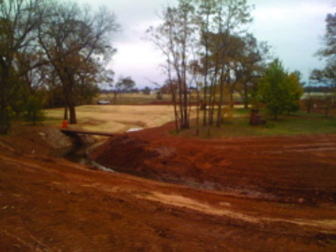
Figure 6. A bank that has been re-sloped. Vegetation will be added once construction is complete.
In-stream structures include various types of rock vanes and toe wood. Each of these techniques not only relieves stress on the banks, but creates scour pools for habitat enhancement. Rock vanes are in-stream structures that stabilize the stream slope to prevent erosion caused by downcutting and widening. They also shift the flow of water away from the bank to the center of the stream, where a scour pool is developed that dissipates energy and provides fish habitat. Several variations of rock vanes exist; examples include constructed rock riffles, cross-vanes, and J-hooks. Constructed rock riffles are diagonally placed rocks that go less than halfway into the stream, while a Cross-Vane extends from bank to bank (Figure 7). They can also be designed as a J-Hook which is a rock structure built in the shape of a J (Figure 8). The material used in the hook portion is spaced apart to allow sediment to flow through and can increase the enjoyment of recreational boaters in larger streams by creating or enhancing riffles. Each technique provides a slightly different benefit and can work together down the stream channel to repair the corridor to its natural state.


Placing a rootwad or bundles of woody vegetation at the toe of a bank, also called toe wood, is another way natural materials enhance aquatic habitat and reduce stream bank erosion. A rootwad consists of a tree’s root mass and 10 to 15 feet of trunk. Its purpose is to create habitat and serve as a barrier between the stream bank and the stream flow. Several rootwads can be used together and are often placed on the outside bend of a meander. Rootwads are installed with the trunk portion entrenched in the stream bank with the root ball exposed to the stream. The trunk is anchored in place using large boulders and soil. Vegetation is added on top of the structure for erosion protection and habitat. The root ball serves as fish habitat and mimics natural root scouring that occurs in a stream. They can be used when stream bank sloping is not an option, typically on vertical banks. The tree in Figure 4 can be used to help stabilize the bank it fell from by using a portion of the trunk and the rootwad.
Immediately following construction, temporary bank protection is installed. This may include coir matting and short-term fast-growing plants. Banks and floodplain are then re-vegetated with native plants. Vegetation in the floodplain slows water during flooding events and protects the soil from erosion. The added vegetation reduces the amount of pollutants flowing into the stream and serves to provide essential habitat both to aquatic and terrestrial species. Trees along the bank provide shade which can keep the water temperature at a healthy level for aquatic organisms. The vegetation also provides a food source from plant debris and falling insects for the aquatic community of the stream.
Each of these methods uses natural materials, some of which can be found within or close to the stream corridor itself. The cost of doing natural stream restoration may be higher than conventional methods, even though materials may be easily obtained. One of the issues with cost is that these techniques are not in widespread use, and there are a limited number of companies with the needed expertise to design and construct natural stream restoration projects. However, those increased costs should be balanced with the benefits to the natural and human communities within the corridor, and beyond. Decrease in sedimentation and other pollutants in the stream will result in lower costs of drinking water treatment. By adding aesthetic and recreational value, an increase in tourism can impact the economy of the entire region by creating jobs and bringing in tax dollars from out of state. Decreased pollution, coupled with increased economic benefit can reach beyond the corridor and have a long-term impact that can outweigh the initial costs.
Safety in Design and Construction
To ensure a restoration project is successful, both in achieving the projects goals and ensuring the safety of users, the combination of an experienced design, and construction team should be a requirement. Flowing water in streams, especially during flooding events, can be dangerous; therefore, the design of structures and streambank slopes should consider the safety of the users. Extremely steep banks should be avoided when possible and in-stream structures must be properly designed and installed to remain stable during flood events. Additionally, if a stream or river has heavy recreational use, an appropriate plan should be put in place to ensure the public does not enter the restoration area during construction.
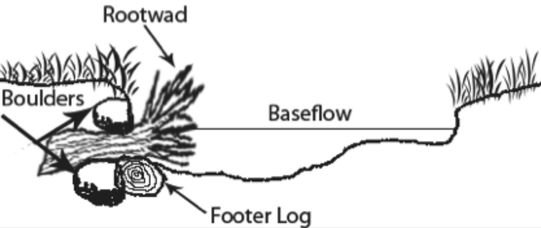
Figure 9. Stream cross-section with rootwad.
Permitting Requirements
Before any restoration project begins, it is important that the responsible party ensures all required permits are approved. This can include permits from the U.S. Army Corps of Engineers, the state’s environmental protection agency, the U.S. Fish and Wildlife, and any other state agency that may have requirements. It is important to research what information and permits are needed in the state where work is being proposed. Section 404 of the Clean Water Act requires a permit to be obtained from the U.S. Army Corps of Engineers if any dredge or fill material is discharged into the waters of the U.S. Since stream restoration involves adding or removing material and can result in material being discharged into the stream or an alteration of the waters, a Section 404 permit is required.
The U.S. Army Corps of Engineers has two different permits: Nationwide Permits (NWPs) and Individual Permits. The purpose of the NWPs is to allow regulation of a general permit for projects that will have minimal impacts with little, if any delay or paperwork. The most common NWPs for stream restoration activities include the NW 13 – Bank Stabilization which allows up to 500 linear feet of bank to be repaired under the NWPs, though a waiver can be obtained for slightly longer areas. The other is NW 27 – Aquatic Habitat Restoration, Establishment, and Enhancement Activities, which includes activities that restore and enhance non-tidal streams.
Individual Permits apply to those projects that exceed the limits and thresholds of NWPs. The review process for Individual Permits is more extensive and requires additional details on the project. Public notice is required on an individual application to allow the public the opportunity to comment on the project and scope of work. The applicant is given the opportunity to respond and that response can be used in the review of the application. For additional information on Section 404 permits visit http://www.usace.army.mil/CECW/Pages/cecwo_reg.aspx and select a state.
In Oklahoma, the Oklahoma Department of Environmental Quality (DEQ) requires a Section 401 water quality certification if an individual Section 404 permit is required. Certification requirements include a written statement clearly stating that a 401 water quality certification is being requested; a copy of the corresponding federal permit application or license; copies of any draft federal permit or license if available; copies of plans, studies, drawings, maps, environmental impact assessment and information regarding endangered, rare or threatened species; project location legal description; description of potentially affected surface water, groundwater or natural resource; if a federal entity requires a mitigation plan, then a copy must be included and a $100 application fee. Other information may be required by the DEQ. A complete list of all requirements can be found on at www.deq.state.ok.us under their rules at Subchapter 3 Sections 252:611-3-1 through 252:611-3-6.
Monitoring
To determine the success of the stream restoration project, monitoring must be done. This should be done in two stages, pre- and post-construction. One indicator of the health of a stream is the macroinvertebrate population. Some macroinvertebrate species are considered sensitive, while others are more tolerant to changes in water quality. It is likely that you will find a larger population of tolerant macroinvertebrates in a stream with impaired water quality and fewer of the sensitive species. Samples should be taken prior to beginning construction to establish a baseline to help measure the success of the project on the stream’s health.
Once construction is complete and vegetation has been reestablished, samples should be taken again. If the stream’s macroinvertebrate population was not balanced, i.e. more tolerant than sensitive species present, that balance should begin to return post-construction. This in turn will help balance the presence of other aquatic species and wildlife, since macroinvertebrates are toward the bottom of the food chain.
Example of Stream Restoration in Oklahoma
Examples of natural stream restoration in Oklahoma is presented in Figures 10 through 12. Before photos show cut banks that are not stable. As the banks continue to erode, land is lost and high levels of sediment enter the stream. The restoration plan for these sites involved reshaping the bank and adding native vegetation. The new banks are stable and have improved habitat compared to the original bank.
Honey Creek Restoration Project in Northeast Oklahoma
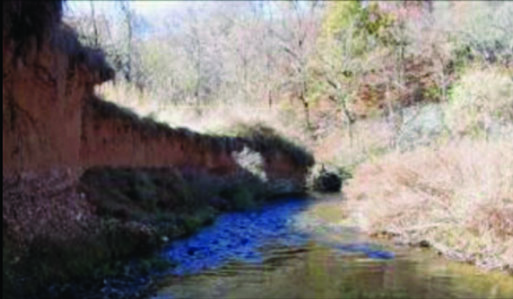
Figure 10. Before
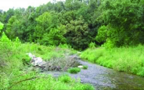
Figure 10. After
Figure 10. Honey Creek Restoration Project in Northeast Oklahoma (before, top; after, bottom).
Illinois River Restoration Project near Tahlequah, Oklahoma
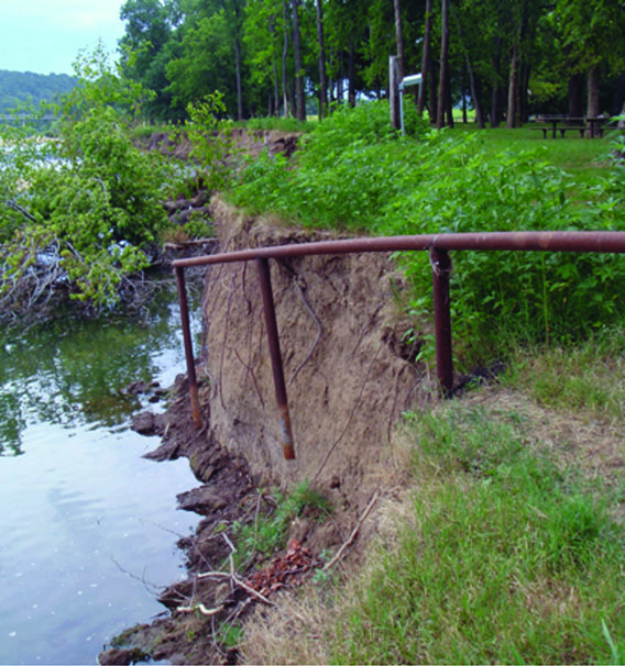
Figure 11. Before
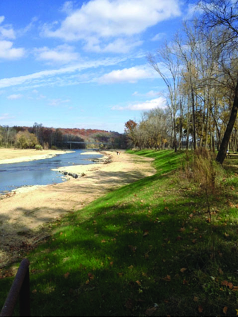
Figure 11. After
Figure 11. Illinois River Restoration Project near Tahlequah, Oklahoma (before, top; after, bottom).
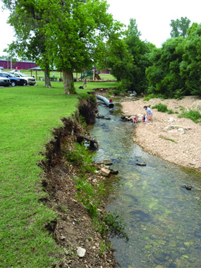
Figure 12. Before
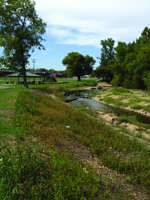
Figure 12. After
Figure 12. Tahlequah Creek Restoration Project in Tahlequah, Oklahoma (before, top; after, bottom).
Conclusion
Restoring streams using these and other natural methods have several benefits. Natural stream restoration not only enhances the natural beauty of the stream corridor, it can reestablish the natural balance of the terrestrial and aquatic communities within it. It can reduce contaminants and decrease the sediment load in the stream resulting in improved water quality. Habitat improvements and additional riffles and pools enhance recreational opportunities that translate into economic benefits for the surrounding communities.
Glossary
Channel bottom – bottom of the stream channel, usually containing rock, sand or silt channel beds.
Dynamic Equilibrium – a system in a steady state since forward reaction and backward reaction occur at the same rate.
Ecosystem – the living organisms and the nonliving environment interacting in a given area.
Floodplain – flat area alongside the stream channel that receives floodwaters and sediment when the stream overflows.
Macroinvertebrates – organisms without a spine and large enough to be seen without a microscope.
Riffle – a rapid, as in a stream.
Riparian Area – area adjacent to a stream channel that is occupied by water loving trees, shrubs, or other plants.
Scour Pool – a type of slow-water habitat unit. Scour pools are formed by scouring, or removal through hydraulic forces, of substrate from the stream channel and deposition of that material elsewhere.
Sediment – sand, silt, clay, gravel, or larger rocks that have been moved by water or wind.
Sedimentation – deposition or accumulation of sediment.
Transitional upland fringe – upland area on one or both sides of the floodplain that delineates the floodplain from the surrounding landscape.
Turbid – not clear or transparent because of stirred-up sediment or other material.
Velocity – speed of something in a given direction.
Further Information and Resources
Oklahoma Cooperative Extension Service Fact Sheets:Riparian Buffer Systems for Oklahoma BAE-1517
Water Quality Series: Riparian Forest Buffers BAE-5034
References
Fischenich, J. Craig. 2003. Effects of Riprap on Riverine and Riparian Ecosystems. U.S. Army Engineer Research and Development Center. ERDC/EL TR-03-4.
Stream Corridor Restoration: Principles, Processes, and Practices. By the Federal Interagency Stream Restoration Working Group (FISRWG)(15 Federal agencies of the US gov’t). GPO Item No. 0120-A; SuDocs No. A 57.6/2:EN 3/PT.653. ISBN-0-934213-59-3. Available online at http://go.usa.gov/Ko0
North Carolina Stream restoration Website,
https://www.bae.ncsu.edu/extension/srp/
Rosgen, D. L. The Cross-Vane, W-Weir and J-Hook Vane Structures…Their Description, Design and Application for Stream Stabilization and River Restoration, http://www.wildlandhydrology.com/assets/cross-vane.pdf
What causes bank erosion? Queensland Natural Resources and Water. http://www.derm.qld.gov.au/factsheets/pdf/river/r2.pdf
Jeri Fleming, J.D.
Environmental Programs Manager
Oklahoma Conservation Commission
Jason Vogel, Ph.D., P.E.
Assistant Professor and Stormwater Specialist
Biosystems and Agricultural Engineering
Alex McLemore, M.S.
Research Engineer, Biosystems and Agricultural Engineering
