Burn Plan for Prescribed Burning
A burn plan helps to determine the safest and easiest way to complete tasks before, during and after a prescribed burn. The most important reason for having a burn plan is to thoroughly think about each action before striking the match. The burn plan will help determine where the burn should be conducted, what type of management is required before burning, how to conduct the burn, when to burn and what should be done after the burn.
A burn plan is a written prescription for the prescribed fire including critical elements
such as the weather conditions under which the burn will be conducted, number of personnel
and duties of each, and the type, amount and placement of equipment needed to safely
conduct the burn. All of this information allows the fireboss to consider all actions
prior to the burn, reducing many problems and complications. A burn plan also helps
the fireboss consider any social impacts of the burn such as: smoke management concerns,
traffic patterns or problems, how to contact neighbors and fire departments, along
with other public safety issues. In rural areas many of these issues may not be of
concern, but in areas associated with urban sprawl, it can be a major problem. Finally,
a well-written burn plan can help reduce liability risk, which is a major concern
for most people conducting prescribed burns. A burn plan can be used to show the amount
of diligence and care used in planning and conducting the burn if some type of liability
issue occurs.
No burn plan is perfect and no two are alike because they are as different as the
burn units for which they are written. Each burn plan may require different information
or planning, with some requiring more information about a specific topic than others.
A burn plan should be written to meet local needs and be adapted to the region. The
more experience a person has preparing plans, the easier it will become to write good
ones. When preparing a burn plan, it is important not to limit implementation by being
too specific with details or prescriptions. For example using weather conditions with
a range that is too narrow and cannot be followed for the duration of the burn is
not a prescription for success. Be sure to include all necessary information, but
do not clutter a plan with pointless information that could cause confusion, or prevent
the execution of a burn, and potentially increase liability.

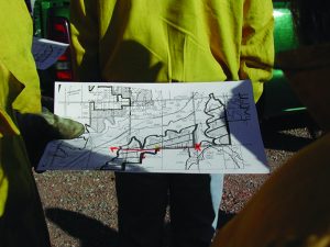
Figure 1. Burn plan map
The following instructions on completing a burn plan and the sample burn plan contained in this publication will assist anyone interested in conducting a prescribed burn. This burn plan provides information appropriate for most situations.
Burn Plan Instructions
Information
Provide basic information about the unit and landowner/manger conducting the burn.
Description of Area to be Burned
Include pasture name, legal description and dominant vegetation type in the burn unit.
Vegetation Present
Describe the main vegetation/fuels present. Example – Tallgrasses, scatted shrubs with cedars <6 ft tall in the upland and solid stands of cedar >15 ft tall along the creek.
Directions from Nearest Town
Provide directions to the burn unit. This may be needed in case of an accident or
escaped fire. In emergency situations, people often forget things as simple as providing
directions to the burn unit. Also, someone not familiar with the area can provide
directions from the burn plan to emergency responders.
Objectives: Explain what the burn will accomplish. Objectives can be singular or multiple,
along with being broad or very specific. Examples – Forage production for livestock,
wildlife habitat management, cedar control, brush suppression, improve forage quality,
hardwood reduction, fuel reduction and wildfire suppression.
Notification
List the names of fire departments, adjoining landowners, and others that need to be notified prior to conducting the burn. This allows the planner to have all phone numbers in one place for quick reference. It also provides a place for the planner to enter the date, time and person notified, which can be helpful if problems arise or for verification of notification.
Pre-Burn Preparations
Describe what should be done before conducting burn.
Management Needed Prior to Burn
Describe management required to prepare for the burn in order to meet objectives. These practices could include grazing management, mechanical treatments to make the burn safer or more effective, or the protection of specific areas or items.
Firebreak Types and Location Around the Burn Unit
Describe the type of firebreaks used and the location of each around the burn unit. Firebreaks can be disked, dozed, roads, cultivated fields or natural breaks like creeks. Example- Firebreaks on the west and north side of the burn unit are disked strips 15 feet in width and the east and south firebreaks are comprised of a two-track pasture road.
For more information about firebreaks see Extension Fact Sheet NREM-2890, Firebreaks for Prescribed Burning.
Fuel Conditions
Record the amount and continuity of fine fuel (herbaceous vegetation) desired for
the burn and actual amount in the burn unit on the day of the burn.
Fine Fuel Amounts: Determined by visual estimation or by clipping and weighing samples.
Fuel Continuity
Describes the amount of coverage or distribution of fuels. This is important for fire spread. Many times there may be adequate fuel amounts, but fuel continuity will not allow the fire to spread or carry across the burn unit.
Prescribed Weather Conditions
Define the weather conditions needed to safely and effectively conduct the burn.
Desired Range
Describes ideal weather conditions for the burn.
Maximum Range
Upper and lower weather conditions allowable for the burn. These ranges allow flexibility in order to account for daily weather variation. Example- Relative humidity desired range 40 percent to 60 percent, maximum range 20 percent to 80 percent.
For more information about weather conditions for prescribed burning, see Extension
Fact Sheet NREM-2878, Fire Prescriptions for Maintenance and Restoration of Native Plant Communities.
Smoke Management Considerations
Identify and list smoke sensitive areas around the burn unit and with what wind direction and dispersion conditions will be needed to reduce smoke impacts. Example- Due to road on west side of burn unit and homes to the south of burn unit, a west or southwest wind is needed to reduce smoke impacts. Attach a smoke dispersion forecast map to the burn plan. Smoke sensitive areas can be roads, communities, airports and houses.
Other Smoke Management Considerations
Category day can be determined from the National Weather Service Fire Weather websites Go to www.weather.gov , select your region from map, then select fire weather).
Dispersion Condition
Information can be found at sites like OK-Fire or Kansas Flint Hills Smoke Management.
For more information about smoke management see Extension circular E-1008, Smoke Management for Prescribed Burning.
Pre-Burn Checklist
This allows the planner to determine if there are potential problems within or around the burn unit and what could be done to reduce or eliminate them. Example – Brush piles are present along firebreaks and will be pushed a minimum of 300 feet inside the burn unit.
Observed Weather
On the day of the burn, record on-site weather conditions before, during and after the burn.
Equipment
List equipment that is needed or might be needed to conduct the burn. It also provides area for recording what was actually on the burn.
Crew Members
List the number of people needed to safely conduct the burn. On the day of the burn, record names of the people comprising the burn crew.
Ignition Plan
Describe the ignition sequence(s) required to ignite the burn safely. This forces the planner to consider in what sequence the burn crew(s) will move around the burn unit igniting the fire and potential problems or hazardous areas that should be addressed. Describe each sequence in writing and draw them on a map of the burn unit. See sample plan on how to write ignition plan and draw an ignition plan map.
Go-No Go Check List
List items needed and tasks to be done prior to conducting the burn. The fireboss should review this list prior to conducting the burn to make sure everything is in order.
Escaped Fire Plan
This is a step-by-step action plan describing what should be done if the fire escapes and the proper procedures for controlling an escaped fire.
Signature Box
Signed and dated by the preparer when the plan is finished.
Prescribed Burn Notification Form
In Oklahoma, this form should be completed and attached to the burn plan. Doing so may limit liability in the event of an escaped fire. A copy of this form should also be filed with the nearest rural volunteer fire department and if in the forestry protection area, a copy must be provided to the local Forestry Services Division office or representative. This portion of the electronic fire plan version will automatically be filled in with information from the fire plan. The only blank that will need to be filled in is the date of previous burn. For more information see Forestry Services Division publication “Notification Requirements and Considerations for Safe and Lawful Prescribed Burning in Oklahoma.”
The following sample prescribed burn plan is to show how the burn plan is filled out, along with examples of smoke management, written and mapped ignition plans.
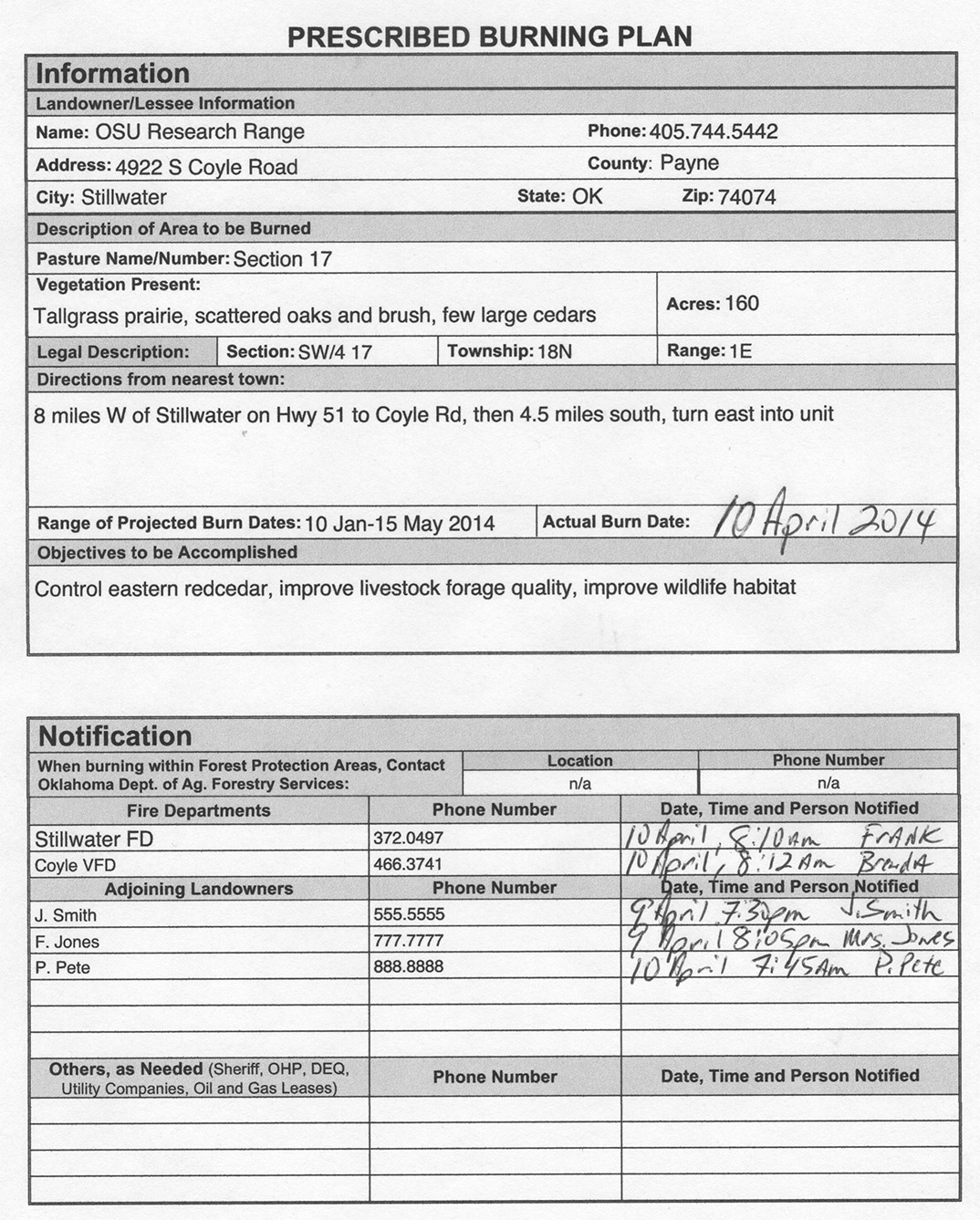
Figure 2a. First page of prescribed burn plan
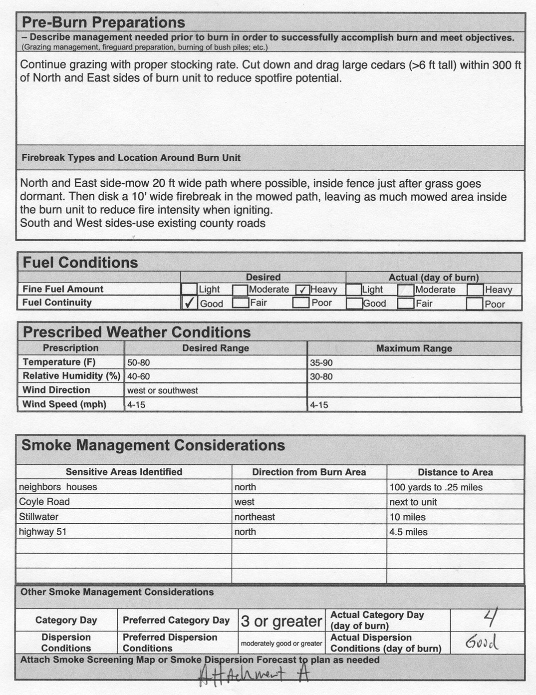
Figure 2b. Second page of prescribed burning plan
Figure 2c. Third page of prescribed burning plan
Figure 2d. Fourth page of prescribed burning plan
Figure 2f. Fifth page of prescribed burning plan
Figure 2g. Sixth page of prescribed burning plan
Figure 3. Burn map attachment
With a southwest wind ignition will start in the northeast corner at point A (see attachment C). Crew will be divided into two groups, crew 1 (east) and crew 2 (west). Equipment will be divided between both groups with 1 UTV and the 200 gallon pumper going with Crew 1 since that firebreak is rough and harder to traverse. The 300 gallon pumper and other UTV will go along the north line. Ignition will consist of strip heaffires using a minimum of 2 torches starting at Point A with Crew 1 going south along the east line stopping at Point B and Crew 2 going west along the north line stopping at Point C. A blackened area of 300 ft wide minimum will need to be established before either Crew can proceed. The UTV’s will patrol their respective lines, while the pumpers will be positioned in problem areas and moved as needed. Once adequate black is established one torch from each crew will begin igniting the headfire and meet at Point D. While the headfire is being ignited equipment and crew will continue to monitor the east and north lines. Equipment will be moved to the west and south lines as needed. Crew 2 should take extra caution along the west side due to traffic on Coyle Road.
Figure 4.
Producer Burn Plan
John R Weir
Research Associate
Natural Resource Ecology and Management
J. Derek Scasta
Graduate Research Associate
Natural Resource Ecology and Management
Russell Stevens
Wildlife and Range Consultant
Samuel Roberts Noble Foundation
Terrence G Bidwell
Extension Range Specialist
Natural Resource Ecology and Management


