Using Drones with Infrared Capabilities to Monitor Fire Behavior
Landowners across the country are constantly looking for ways to innovate and become
more efficient in their everyday practices. Land managers who choose to practice prescribed
fire are no different. Landowners know adequate equipment and personnel are needed
to conduct each burn as safely as possible. With the advancement of technology, landowners
now have access to new cutting-edge technology that could assist in conducting prescribed
fires, making it safer and possibly require less people or free up crew members to
assist with other tasks. The use of unmanned aerial vehicles (UAV)’s or drones in
agriculture is a rapidly growing practice that is being applied to all corners of
the industry. Some are using UAVs to
measure forage quantity and quality in their pastures, while others use drones to
monitor animal movement or behavior, as well as inspect infrastructure such as fences.
Another good use for UAVs can be making prescribed fires safer and easier to conduct
by having an Infrared camera on the UAV to monitor fire behavior.
Why Use a UAV with Infrared Technology?
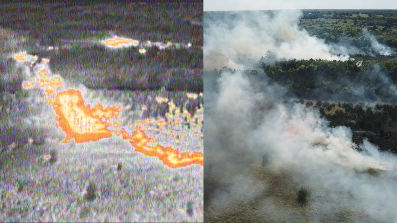
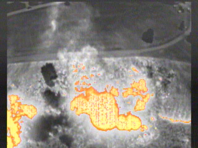
Conventional cameras on drones are referred to as RGB (red, green and blue) cameras, because they show only the visible light spectrum seen with the naked eye. All objects give off infrared energy, which is a non-visible spectrum of light. This also is known as a heat signature. A infrared camera (IR) detects the heat energy and creates an image on a screen visible to humans, letting them see heat signatures. As you can imagine, fire gives off some very intense heat signatures, but also it gives off a lot of smoke. Depending on what kind of fuel is being burned, that smoke can severely inhibit someone from seeing exactly where the fire is and how it is behaving (Figure 1). Many times, prescribed fire crew members must stand in heavy smoke to try to detect spotfires or monitor problem areas.
Figure 1. The Infrared camera allows the operator so see through smoke to monitor fire behavior.
The same fire viewed with two different cameras, conventional RGB camera (right) and
infrared (left).
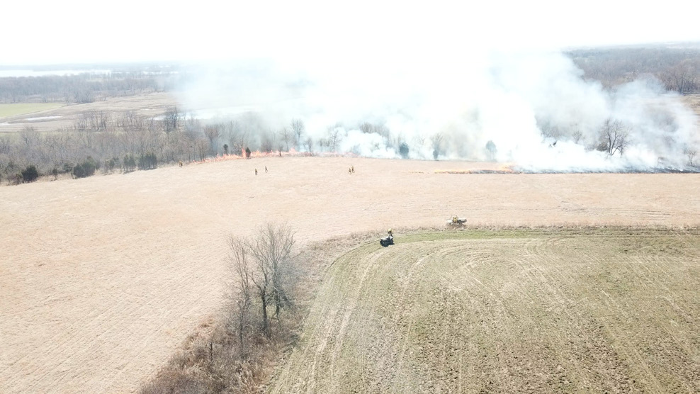
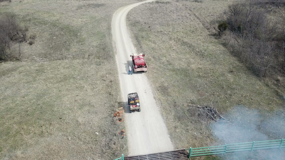
This can aggravate breathing and eyesight. With an Infrared camera on a UAV, the operator now has the ability to see through the smoke with a bird’s eye view. The operator can track how fast and what direction the fire is moving. Thus, reducing the number of people needed to watch problem areas or that have to stand in areas of heavy smoke. This technology has already been implemented by many wildland firefighters, to monitor the behavior of large wildfires. Great utility has been found in using the same technology on prescribed fires as well (Figure 2).
Figure 2. Using a UAV while conducting a prescribed burn allows the operator to monitor smoke and fire behavior, then report it to the fire boss.
How Can an IR UAV Assist on a Prescribed Burn?
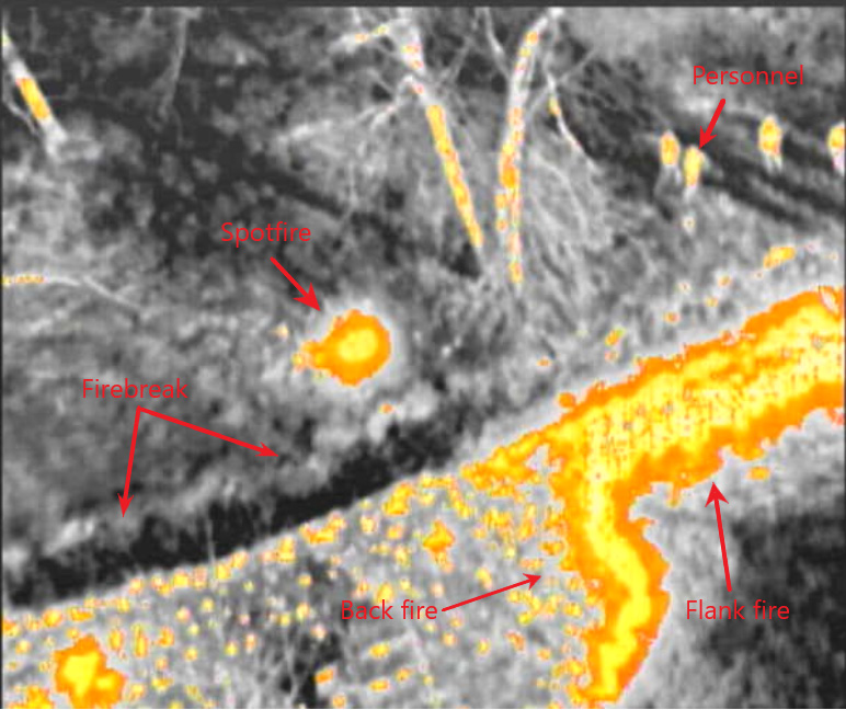
On most prescribed burns, personnel are assigned with the task of traveling along the firebreaks, acting as lookouts for spotfires and escapes, while others are igniting the fire along other parts of the burn unit. This job is often uncomfortable because the crew has to travel back and forth along the firebreak and constantly be in the smoke. The smoke is sometimes too dense to see through, as well as often leaving crew members with irritated eyes, runny noses and dry coughs for a short time. Patrolling the fire line is extremely important, due to the fact that crew members can monitor the fire behavior and alert the rest of the crew if the fire jumps or creeps through the firebreak and is burning outside of the burn unit. To reduce the impact of smoke irritation and possible injury, a single operator with an IR equipped UAV in the air can easily and effectively monitor a much larger area from a safe distance away. An operator with a radio has the potential to see a spotfire or escape as soon as it occurs and can relay the location to the suppression crew who is positioned nearby and out of the smoke. They can then promptly extinguish it, all without putting crew members in the smoke for extended periods (Figure 3).
Figure 3. Infrared images are clear enough to identify spotfires, firebreaks, personnel and fire types.
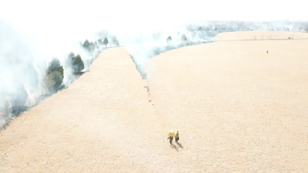
The fire boss also can utilize these IR UAVs by keeping up with crew member locations, making movements of personnel and equipment with actual “eyes on”, instead of relying on secondhand radio communication (Figure 4). Also, the IR UAVs are used to monitor the fire behavior and areas not safe for crew members. Overflights of the burn unit also can help determine areas that did not burn and need to be reignited. The potential uses of UAVs by prescribed fire personnel is limitless (Figure 5).
Figure 4. UAV use helps to keep track of personnel and equipment placement, then the controller can radio the crew to help direct them safely around the burn unit.
Figure 5. An infrared camera gives the operator the ability to identify hot spots along the edge of the burn unit. This makes mop-up easier and helps to reduce problems.
Tips and Tricks for Using UAVs on Prescribed Burns
- Read and understand the user manual before flying and become comfortable with flying your UAV before taking it on a prescribed burn.
- Be sure all updates to the operating system and controllers have been installed.
- Be sure all equipment works correctly and all extra batteries are charged.
- If applicable, have a system set up to recharge batteries on location to keep the UAV in the air as long as possible. Using a 110v outlet or converter in a vehicle is the easiest way to do this.
- The operator’s only job is flying the UAV, watching the fire line and reporting to the fire boss. The operator cannot effectively monitor the fire if they have to go help the other members of the crew
- Before flying, be aware of all aerial obstacles, such as: tall trees, power lines, cell towers, etc.
- If possible, conduct a practice run. Fly over the burn unit to get a bird’s eye view before the fire is lit. This will aid in discovery of obstacles and possible hazards.
- Conserve battery power, fly only when needed because the battery life is the most limiting factor on UAV flight time. For example, the initial backfire may not need to be monitored if firebreaks are adequate, but flank fires with shifting winds may need more attention.
- If applicable on large or complicated burn units, using two drones and two operators can be very useful. When one drone has to come back to replace a battery, the other drone can launch and be monitoring while the other is changing batteries. Even if using one drone with only a typical RGB camera, it is still useful at elevation.
- If recording the burn, be sure all memory cards are empty before recording to ensure they do not run out of space.
- Ensure landing and takeoff zones are away from obstacles and free of tall vegetation.
- While in the air, constantly monitor altitude, distance and battery life, as well as heeding all warnings given by the operating system, if applicable.
UAV Licensing and Legality
Since the use of UAVs is becoming more common, restrictions and regulations have come about to ensure the safety of all who use the airspace above us. The basic legality of flying your UAV, defined by the Federal Aviation Administration (FAA) is as follows:
- Recreational users are not required to get a Part 107 license, only if their operations are for purely flying for fun. All other operations would require a Part 107 license.
- All drones between 0.55 and 55 pounds must be registered with the FAA.
- Mark the UAV on the outside with the registration number and carry proof of registration.
- Flying UAV’s for use on prescribed fires is likely not protected under the recreational/personal use rule due to the nature of the flights not being strictly for “personal enjoyment.” Best practice for this type of operation would be to obtain a Part 107 license and operate under the knowledge and guidelines gained from that credential provided by the FAA.
- Fly UAV at or below 400 feet above the ground level when in uncontrolled (Class G) airspace.
- Obtain authorization before flying in controlled airspace (Class B, C, D, and E). You can obtain authorization in three ways:
- Low Altitude Authorization and Notification Capability
- DroneZone
- A written agreement with the FAA for fixed flying sites. For more information about fixed flying sites, contact them at UAShelp@faa.gov.
- Please note: Flying UAVs in certain airspace is not allowed. Classes of airspace and flying restrictions can be found on the FAA B4UFLY app.
- Always keep your UAV within your visual line of sight, or within the visual line-of-sight of an observer who is colocated (physically next to) and in direct communication with you.
- Flying at night may occur only under the two risk mitiga-tion measures. First, the remote PIC must have completed either an initial knowledge test or recurrent training that has been updated to include night operations and the small unmanned aircraft must have anti-collision lighting that is visible for at least three statute miles. More details for this operation are provided here see Section 5.7.2.
- For flight operations over any person or vehicles please refer to chapter 8 of the AC 107-2A document for more details on how to perform these operations if there is a need.
- Never interfere with emergency response activities such as disaster relief, any type of accident response, law enforcement activities, firefighting or hurricane recovery efforts.
- Never fly under the influence of drugs or alcohol. Many over-the-counter medications have side effects that could impact your ability to safely operate the drone.
- Do not operate the drone in a careless or reckless manner.
The FAA has narrowly construed the ideas of what a “Recreational flyer” is and that it is likely in the best interest for anyone performing flights for prescribed fire to obtain a Part 107 license and follow the rules and regulation closely or you are still subject to liability. Obvious areas to avoid would be near or around any airports and near active military installations. Often, airports and military installations have controlled airspaces around them as large as several dozen square miles. Within these airspaces, it is critical to know the ceiling height at which you can legally fly. The FAA has delineated all controlled airspaces at their website. Some not-so-obvious areas would be federal parks, over people (without a proper waiver), over public roadways (as moving cars are considered over people), electrical power-generating facilities, a dam that is regulated by the state or federal government and critical infrastructure designated by the federal government.
IR UAV Set-ups
There are multiple options for those who want to use infrared imaging to help conduct prescribed burns. A quick web search will bring up dozens of sites with set-ups ranging from entry level to professional and commercial applications. Many UAV dealers have ready-to-go UAV packages with both IR cameras and high-definition RBG cameras. Other options are to add an IR camera to the drone set up you may already own, for which there are many options as well. However not all UAV’s will be able to support the extra weight or have the infrastructure needed to mount another camera. Some research will be needed to ensure the IR camera will successfully mount to what you already have. Pricing can range anywhere from the lower end and entry level of about $3,000 to the more sophisticated and professional end of about $10,000. Prices vary widely on just the individual IR cameras, some come with accessories and mounting hardware and some do not. Many people may be intimidated by the technology used in modern UAVs, but most of the UAVs produced for the consumer market are very user friendly and easy to learn how to pilot. Many of them come with anti-collision sensors and programming to land safely once a certain battery level is reached. Many options also have the ability to fly autonomously with pre-determined flight paths via GPS data delineated by the operator, making it much easier to observe the screen. Flight times can range anywhere from 20 minutes to 40 minutes per battery.
The civilian UAV industry is a new field that is constantly improving and changing. This results in new rules and regu-lations being established almost yearly. It is the operator’s responsibility to be aware of any and all recent regulation changes. Changes can always be found at faa.gov/uas/
Helpful Links
- How to Register your UAV
- Acquire UAV pilot license
- Recreational use rules
- LAANC (Low Altitude Authorization and Notification Capability)
- DroneZone
- Part 107 waivers (for commercial operations)
- Advisory Circular about regulation changes as of 2/1/2021 (AC 107 - 2A)
B4UFLY Mobile App available for IOS and Android
This work is/was supported by the USDA National Institute of Food and Agriculture, Renewable Resource Extension Act project 1011212.
Cole Fagen
Graduate Research Assistant, Natural Resource Ecology and Management
John R Weir
Associate Extension Specialist, Natural Resource Ecology and Management
Dillon Payne
Spatial and Applied Agriculture Technology Manager, Noble Re-search Institute

